Entry Points:

About Ennis
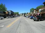
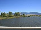
Ennis sits on the banks of the Madison River in the Madison River Valley in southwest Montana. The valley is several miles wide and occupied with ranchland where cowboys run cattle. Some parts of the valley are under irrigation where hay is the main crop cultivated. Mountains rim the valley, the closest ones being the Tobacco Root Mountains, whose foothills begin at the northwest edge of town. Across the valley, with peaks reaching above 11,000 feet. The Gravelly Range lies to the south.
Gold was discovered in Alder Gulch in 1863, bringing a “rush” of prospectors to the area. William Ennis arrived two months afterwards and staked a homestead at this site. Virginia City, located some ways to the west boomed during the mining days and became the seat of Madison County, but today Ennis is its largest town. It is surrounded by a large and unsettled area with many mountains and few towns. The population of Ennis stood at 840 in the 2000 census.
The Madison River has its source in Yellowstone National Park, and cuts through the south end of the Madison Mountain Range and approaches Ennis from the south. To the north it flows to Three Forks, where it joins the Gallatin and Jefferson Rivers to form the Missouri River. Thanks to the Madison River, along with the many mountains, Ennis is a center for anglers and hunters who come to Ennis for lodging and supplies for their trips to the area.
U.S. Highway 287 passes through Ennis as it follows the course of the Madison River. Montana Highway 287 runs westward from Ennis towards Virginia City. When passing through Ennis, make sure to not mistake the two highways, which share the sane number! U.S. Highway 287 turns at the main intersection in town, taking the east and north directions. Montana Highway 287 heads west. U.S. Highway heads north past Ennis Lake to Norris. It heads east across the valley and then turns south.
The elevation at Ennis lies in the narrow range between 4,942 at the river, to 4,960 feet on the west side of town. Its coordinates are 45º20'46" N 111º43'56" W. With its northerly latitude and high elevation it has a cool climate and short growing season.
For More Information:
See www.ennismontana.org for the city’s official website, and en.wikipedia.org/wiki/Ennis_Montana for its Wikipedia article.