Entry Points:

About Madison County
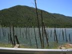
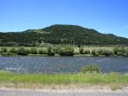
Madison County covers 3,603 square miles in the southernmost portion of Montana. A short section of the Idaho border reaches up to its southern boundary. It is named after the Madison River, which flows into its southeast corner, originating in Yellowstone National Park, and flowing northward through the Madison River Valley.
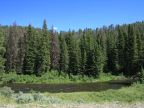
The Madison Mountain Range covers the eastern boundary of Madison County, with lofty peaks reaching above 11,000 feet in elevation. These overlook the Madison River Valley on the east, and to the west of it lie the Gravelly Range, and further north the Tobacco Root Mountains. Mountains cover a large area in the south of the county. On the west boundary, three rivers, the Big Hole RIver, the Beaverhead River and the Ruby River, converge to form the Jefferson River which flows along the northern boundary of the county, and eventually meets the Madison River.
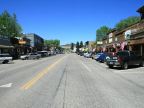
The population of Madison County was just 7,691 at the 2010 census, giving it a population density of about 2 people per square mile. The county seat is at Virginia City, but Ennis is the largest town, at just 840 people. The elevation of the valleys is close to 5,000 feet, with the lowest elevation at 4,200 feet where the Jefferson River leaves the county. The highest point is Hilgard Peak at 11,316 feet.
U.S. Highway 287 follows the Madison River through Madison County, passing through Ennis. Montana Highway 41 passes through the valley surrounding the Jefferson River on the west side of the county, and Montana Highway 287 connects form there to Ennis. Montana Highway 84 reaches into the northeast corner of Madison County, connecting to Bozeman and Interstate 90.
For More Information:
See Madison County’s official site at www.madison.mt.gov.
See also Wikipedia's article on Madison County.