Earthquakes!
Few natural events cause as much fear in people as
earthquakes. They remind us that the Earth is always
changing and renewing itself and that this sometimes occurs
violently and without warning. Earthquakes happen when stored
energy is suddenly released by movement along a fault. A fault is a
fracture that allows blocks of rocks to slide past each other. Tectonic
forces gradually apply stress the fault but friction along the fault
keep the two sides locked in place. Eventually, the stress builds
to the point where frictional forces locking the fault are exceeded
and opposite sides of the fault suddenly slip past each other,
releasing the stored energy. Some of this released energy radiates
away from the fault surface as seismatic waves, which we feel as an
earthquake. The earthquakes in southwestern Montana are part of
Intermountain Seismic Belt, a zone of frequent earthquake activity
that extends about 800 miles from northwest Montana southward
through Yellowstone National Park, through the Salt Lake City
area, and all the way to southwestern Utah. A branch of the
Intermountain Seismic Belt extends from Yellowstone about 300
miles west to the Idaho-Oregon border. The Intermountain Seismic
Belt results from gradual stretching of the North American tectonic
plate as if it interacts with the Pacific tectonic plate.
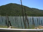
On August 17, 1959, a magnitude 7.3 earthquake struck Hebgen
Lake about 12 miles northeast of here. The earthquake ruptured two
faults, the Hebgen Lake fault and the Red Canyon fault, and caused
parts of the Hebgen Lake basin to subside as much as 22. The
sudden tilting of Hebgen Lake caused a large wave-a sciche- to
wash back and forth across the lake overtopping Hebgen Dam
and sweeping shoreline cabins off thir foundations. It also shook
loose a mountainside-the 37 million cubic yard Madison Canyon
lanside-that dammed the Madison River to form Earthquake
Lake. The landslide buried part of a campground, killing 26 people.
The Habgen Lake Earthquake caused a large section of a mountain
to break loose and slide down into the canyon, damming the river
and killing 26 people. The arrow shows the direction the mountain
slid. Unset image shows a camp in the sand of Duck Creek 1959.
Madison Canyon Quake Site. [Landslide with river in foreground.](
Geo-Facts:
Montana is one of the more seismically active states in the United States. An average of five earthquakes occur here every day. Most
are so tiny that a sensitive seismograph is needed to detect them.
The Hebgen Lake earthquake was felt over an area 600,000 square miles including all of Montana and from Bantt, Canada to
Provo, Utah, and from western North Dakota to Seattle, Washington.
Earthquake strength is measured using the Richter scale, which measures the seismic energy released by a quake and by the Mercalli
scale, which measures the intensity by calculating the effects of it on the Earth's surface, humans, and man-made structures.
Geo-Activity
Movement along the Hebgen Lake and Red Canyon faults offset the land surface to forma a fault scarp that runs like a scar along the
north side of Hebgen Lake. Look for these fault scarps at the base of the mountains as you drive east along Hebgen lake.